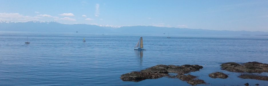
Anderson Hill Park is in the seaside community of Oak Bay, one of the thirteen communities in the Capital Regional District of British Columbia. Even when the flowers, Easter lilies, shooting stars, and camas lilies, are not in bloom Blueberry Hill draws admirers to its 63 acres at 125 feet above sea level. Created from property originally proposed as a residential lots, Blueberry Hill provides suburb views over McNeill (Shoal) Bay and Juan De Fuca Strait. On clear days this park provides awesome views of the Olympic Mountains as well as snow topped Mt. Baker of the Coastal Range in Washington State. Trial Island with its three towers and light house form the forefront of the portrait. Detailed sketches of the plants found in this park are provided at the main entrance to the park. You can also look across to Walbran Park on the western hilltop. Dedicated to Al Unwin, the director of Oak Bay Parks, Blueberry Hill also named Anderson Hill. The hilltop was named after Alexander Caufield Anderson. He was an explorer, agriculturist, and artist, who arrived with the Hudson Bay Company and stayed on as the first customs collector and postmaster for Victoria. The footpath through the park is partly well marked by wood chips or gravel and other sections are across the rocky outcrops. The route is about half a kilometer along the perimeter of the park. There are a few garry oak trees and small shrubs in the parkland.
Geographic Location N48º 24’ 49” W123º 18’ 22”
Anderson Hill Park can be reached from the Trans-Canada Highway. Continue along the Hwy 1 into Victoria as it becomes Douglas Street. Turn off Douglas onto Hillside Avenue to head east. Stay on Hillside Avenue as it becomes Lansdowne Road. Continue along Lansdowne Road to reach Foul Bay Road. Continue along Foul Bay Road to reach Fairfield Road. Turn left onto Fairfield Road and continue along to Beach Drive. Turn left onto Beach Drive and continue along the shore McNeill Bay. Turn left onto Newport Avenue. Turn onto Island Road and watch of the park sign. Parking is available beside Island Road. Access to the park is also available through Transit Road although the trail is difficult to spot. It lies between houses #545 and #577. City busses provide access off of Transit Road.
